 The Significance of 3D Heightmaps in Interactive Environments:
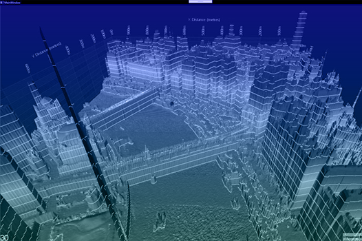
3D heightmaps are digital representations of terrain surfaces, depicting variations in elevation across landscapes. They use polygons, which are geometric shapes, to construct the contours and features of the terrain, enabling realistic rendering in three-dimensional space. In modern "atom" rendering techniques, each pixel or atom of the image is individually processed, allowing for more intricate and detailed rendering of heightmaps. These heightmaps serve as crucial components for various industries venturing into the 3D interactive market, providing a foundational framework for creating immersive virtual environments. By accurately capturing the topography of landscapes, heightmaps enhance the realism and authenticity of virtual worlds, facilitating engaging experiences for users across sectors such as gaming, architecture, GIS, and smart cities.
Heightmaps are indispensable tools for industries exploring 3D interactivity due to their versatility and applicability across diverse sectors. In gaming, they lay the groundwork for expansive virtual landscapes, enabling developers to craft immersive worlds with intricate terrains and natural features. For architecture and civil engineering, heightmaps aid in visualizing and analyzing site conditions, facilitating informed decision-making in urban planning and infrastructure development. In GIS, they serve as essential components for spatial analysis and data visualization, empowering professionals to extract valuable insights from geographical data. In the realm of smart cities, heightmaps support holistic planning and development strategies, enabling stakeholders to simulate urban scenarios and optimize resource allocation for sustainable urban growth. Overall, heightmaps play a pivotal role in driving innovation and creativity in the burgeoning field of 3D interactive technologies.
Game Development:
In game development, 3D generated height maps and terrain generation are instrumental in crafting immersive virtual worlds. With the advent of Apex Engine, developers now have access to advanced tools that streamline the integration of height maps, allowing for the creation of intricate and realistic landscapes. By leveraging AI generation using LLM models and libraries for historical and modern maps, developers can infuse authenticity into their game environments. This integration also enables real-time interaction during the development phases, empowering developers, testers, and clients to explore and provide feedback seamlessly.
Architecture and Civil Engineering:
For architecture and civil engineering, 3D generated height maps revolutionize the design process by offering detailed insights into spatial planning and construction. With Apex Engine's capabilities, architects and engineers can visualize architectural projects and infrastructure developments with unparalleled accuracy. By incorporating AI-generated heightmaps derived from historical and modern maps, stakeholders gain valuable context and can make informed decisions throughout the design and construction phases. Real-time interaction with these 3D models enhances collaboration and facilitates iterative design processes.
GIS (Geographic Information Systems):
Geographic Information Systems (GIS) rely heavily on 3D generated height maps for spatial analysis and data visualization. With Apex Engine, GIS professionals can generate high-fidelity terrain models that provide critical insights into geographical features and land use patterns. By integrating AI-generated heightmaps based on historical and modern maps, GIS applications become more robust and accurate, enabling users to extract actionable insights for urban planning, environmental management, and disaster response. Real-time interaction with these models enhances decision-making and fosters collaboration among stakeholders.
Smart Cities:
In the context of smart cities, 3D generated height maps play a pivotal role in urban planning and development. With Apex Engine, city planners can simulate various urban scenarios and assess the impact of infrastructure projects on the surrounding environment. By incorporating AI-generated heightmaps derived from historical and modern maps, smart cities can leverage data-driven insights to optimize transportation networks, manage resources efficiently, and enhance overall livability. Real-time interaction with these 3D models facilitates stakeholder engagement and empowers communities to shape the future of urban landscapes collaboratively.
Revolutionizing Industries: AI-Powered 3D Terrain Generation:
As industries across game development, architecture, GIS, and smart cities embrace 3D generated height maps and terrain generation, the integration of AI-driven technologies becomes increasingly essential. Apex Engine stands at the forefront of this revolution, providing advanced tools and capabilities that streamline the development process from design to post-production. By harnessing AI generation for heightmaps, developers and stakeholders can unlock new possibilities for creativity, accuracy, and collaboration, ultimately driving innovation and progress across diverse industries.